Gold Mine For Sale Arizona | Little May Gold
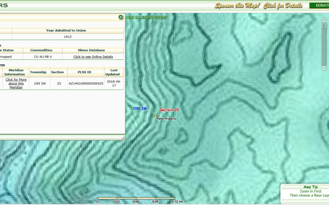
aka: Fisher Property
Prospect in Yavapai county in Arizona, United States with commodities Copper, Gold, Lead, Vanadium
Gold Mine For Sale Arizona: The Little May Group is set in the western foothills of the Bradshaw Mountains in a well-known gold-rich area near the Hassayampa River of Arizona. It is located primarily on Arizona state land. It has been located, staked, and approved for exploratory mining on a mineral lease with the Arizona Land Trust.
Visit Our Sponsor: Gold Rush Newsletter
Geologic information
Identification information
| Deposit ID | 10137481 |
|---|---|
| MAS/MILS ID | 0040250728 |
| Record type | Site |
| Current site name | Fisher Property |
| Alternate or previous names | Little May Group |
Geographic coordinates
| Point of reference | Ore Body |
|---|---|
| Geographic coordinates: | -112.53135, 34.17505 (WGS84) |
| Elevation | 1097 |
| Location accuracy | 100(meters) |
|
Political divisions (FIPS codes) Yavapai(county) Arizona(state) United States(country) North America(continent) Land(continent) USGS map quadrangles Wagoner(quadrangle 1:24,000 scale) Bradshaw Mountains(quadrangle 1:100,000 scale) Prescott(quadrangle 1:250,000 scale) Hydrologic units (watersheds) Hassayampa(hydrologic unit) Lower Gila-Agua Fria(hydrologic accounting unit) Lower Gila(hydrologic subregion) Lower Colorado(hydrologic region) |
|
Geographic areas
| Country | State | County |
|---|---|---|
| United States | Arizona | Yavapai |
Public Land Survey System information
| Meridian | Township | Range | Section | Fraction | State |
|---|---|---|---|---|---|
| Gila and Salt River | 010 N | 003 W | 25 | SW | Arizona |
Commodities
| Commodity | Importance |
|---|---|
| Copper | Secondary |
| Gold | Primary |
| Lead | Secondary |
| Vanadium | Tertiary |
Nearby scientific data
| Ore Body (1) | Early Proterozoic granitic rocks |
|---|
Economic information
Economic information about the deposit and operations
| Development status | Prospect |
|---|---|
| Commodity type | Metallic |
| Significant | No |
Mineral rights holdings
| Type of mineral rights | Located Claim |
|---|
Land status
| Ownership category | Mixed |
|---|
Ownership information
-
Type Owner Owner H. W Fisher Home office Arizona Year 1946
Reference information
Links to other databases
| Agency | Database name | Acronym | Record ID | Notes |
|---|---|---|---|---|
| U.S. Bureau of Mines | Minerals Availability System | MAS | 0040250728 |
Bibliographic references
-
Deposit
ADMR LITTLE MAY GROUP FILE
Reporter information
| Type | Date | Name | Affiliation | Comment |
|---|---|---|---|---|
| Reporter | 04-NOV-1983 | Admr | U.S. Bureau of Mines |
Arizona Gold Mine – Little May Gold Geology Characteristics
Early Proterozoic granitic rocks
Wide variety of granitic rocks, including granite, granodiorite, tonalite, quartz diorite, diorite, and gabbro. These rocks commonly are characterized by steep, northeast-striking foliation. (1600-1800 Ma)
| State | Arizona |
|---|---|
| Name | Early Proterozoic granitic rocks |
| Geologic age | Early Proterozoic |
| Lithologic constituents |
Major Igneous > Plutonic > Granitic > Tonalite (Pluton)
Igneous > Plutonic > Granitic > Granodiorite (Pluton)
Igneous > Plutonic > Granitic > Granite (Pluton)
Minor Igneous > Plutonic > Dioritic > Diorite (Pluton)
Igneous > Plutonic > Gabbroic > Gabbro (Pluton)
Igneous > Plutonic > Dioritic > Quartz-diorite (Pluton)
|
| Comments | ~ 1.6 – 1.8 Ga |
| References |
Richard, S.M., Reynolds, S.J., Spencer, J.E., and Pearthree, P.A., 2000, Geologic Map of Arizona: Arizona Geological Survey Map 35, 1 sheet, scale 1:1,000,000.Anderson, P., 1989, Stratigraphic framework, volcanic-plutonic evolution, and vertical deformation of the Proterozoic volcanic belts of central Arizona, in Jenney, J.P., and Reynolds, S.J., editors, Geologic evolution of Arizona: Arizona GeConway, C.M., and Silver, L.T., 1989, Early Proterozoic rocks (1710 – 1615 Ma) in central and southeastern Arizona, in Jenney, J.P., and Reynolds, S.J., editors, Geologic evolution of Arizona: Arizona Geological Society Digest 17, p. 165-18DeWitt, E., 1989, Geochemistry and tectonic polarity of Early Proterozoic (1700 – 1750 Ma) plutonic rocks, north-central Arizona, in Jenney, J.P., and Reynolds, S.J., editors, Geologic evolution of Arizona: Arizona Geological Society Digest |
| NGMDB product | |
| Counties | Cochise – Coconino – Gila – Graham – La Paz – Maricopa – Mohave – Pima – Pinal – Yavapai – Yuma |
Source: https://mrdata.usgs.gov/mrds/show-mrds.php?dep_id=10137481
Part of the U.S. Department of the Interior, the USGS began in 1879 to study the nation’s lands and resources. Today, we monitor, analyze, and predict Earth’s changing systems. Our science provides clear, reliable data that protects lives and property, supports energy and mineral decisions, strengthens water infrastructure, and promotes economic growth.
by WebSuite Media – Digital Marketing & AI Systems Consulting – Helena, MT